

 How to survive a power outage in winte
 Monarch Butterflies That Should Have Migrated South Have Yet to Leave Canada
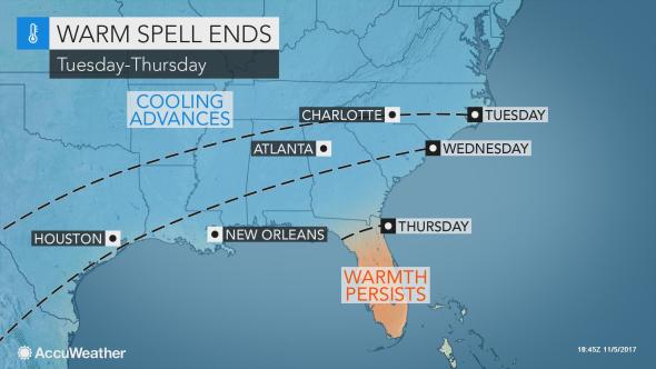 Rain, cooler air to sweep record-challenging warmth out of southern US this week
 Franken-Philippe Bringing Damaging Winds
 Exploring Solar Storms
 Tropical Storm Philippe Drenches Florida and Cuba
 Hole in the ozone layer over Antarctica
 The history of the barometer
Rain, cooler air to sweep record-challenging warmth out of southern US this week
Rain and cooler air will slowly seep into the southern United States this week, erasing the current record-challenging warm spell.
Warmth more typical of early fall will once again pour across a large portion of the South on Monday. Highs from the upper 70s to the middle 80s are expected along and south of the I-20 and I-85 corridors.
Charlotte, North Carolina; Columbia, South Carolina; Augusta, Georgia; Shreveport, Louisiana; and Houston are among the communities that will challenge record highs.

Several cities have already tied or broke record highs since the start of November, according to AccuWeather Meteorologist Faith Eherts.
“Atlanta tied a record high on Saturday with a high of 80 F, while highs in the lower 90s caused Dallas to break records on Saturday and last Thursday,” she said.
Not all of the South will bask in Monday's warmth. The passage of a cold front will shave 10-15 degrees Fahrenheit off Sunday’s highs from Nashville to Little Rock, Arkansas, to Oklahoma City.
The warmth will continue to get trimmed to the south and east as the week progresses.
Cooler air will seep down to Raleigh, North Carolina, and Dallas on Tuesday, while another day of widespread and record-challenging highs in the 80s unfolds from central Texas to eastern South Carolina and Florida.
The cooler air will make more significant progress at midweek, reaching the I-20 corridor, before sweeping over the I-10 corridor later in the week.
Highs later this week will generally range from the 50s along I-40 to within a few degrees of 70 F along the western and central Gulf Coast.
Temperatures will go from soaring 10-20 degrees Fahrenheit above normal during the current warm spell to being held near or below normal later this week.
Highs this time of year typically range from the middle and upper 60s along I-40 to the middle 70s across the central Gulf Coast.

Only central and southern Florida peninsula will not experience a significant drop in temperatures.
Despite the cooldown, the risk for frost and freezes is not expected to return to the I-20 corridor and points southward.
In addition to grabbing jackets out of closet, residents of the South will also need to keep umbrellas handy as the cooler air returns.
“The cold front sinking through the region will help promote clouds, showers and thunderstorms,” Eherts said. “That will limit sunshine and mitigate rising temperatures.”
Widespread heavy rain and the risk of flash flooding is not expected. The rain is instead expected to cause disruptions to outdoor plans and slower travel.
Rain and low-hanging clouds may lead to flight delays. This includes at Dallas and Little Rock, Arkansas, on Wednesday and Atlanta and Charlotte, North Carolina, both Wednesday into Thursday.
The one benefit of the rain will be to help ease the abnormally dry to moderate drought conditions that the U.S. Drought Monitor reports are plaguing several areas.