

Severe weather to threaten portions of central US several days in a row
Spotty thunderstorms that develop over the High Plains are likely to bring isolated severe weather incidents from the western part of the Dakotas to western Texas into the start of the weekend.
Where dry air from the mountains and deserts meets up with more humid air from the Gulf of Mexico, showers and thunderstorms will be common over the High Plains during the spring and early summer.
The weather pattern into Thursday will be no exception.
"Widely scattered storms over the Plains may become strong to locally severe along that boundary between the dry and moist air each day,"according to AccuWeather Storm Warning Meteorologist Richard Schraeger.
On Tuesday afternoon, isolated storms produced hail as large as baseballs and wind gusts up to 80 mph in western Texas.
During Wednesday evening, storms may tend to focus right along the dry and moist boundary from western Texas to the western part of the Dakotas and eastern Montana.
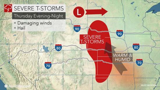
On Thursday, a disturbance is forecast to move slowly eastward from the northern Rockies.

This system may help to focus strong to locally severe thunderstorms over parts of the northern and central Plains toward nightfall.
Isolated flash flooding and strong wind gusts may be the greatest threats from the Thursday night storms. However, incidents of hail are also likely.
While a small number of tornadoes may be spawned from the strongest storms into Wednesday night over the High Plains, the overall setup is not conducive for a tornado outbreak.
It is possible that conditions may become more favorable for a few tornadoes with the approach of the storm from the northern Rockies beginning Thursday night and perhaps continuing into this weekend.

The greatest risk may focus on, but may not be limited to areas from Nebraska and eastern Wyoming to parts of Oklahoma and northern Texas.