

Few showers and storms Thursday
Thursday's showers give us our last chance to enjoy some cooler temperatures before another heat wave bakes East Tennessee.
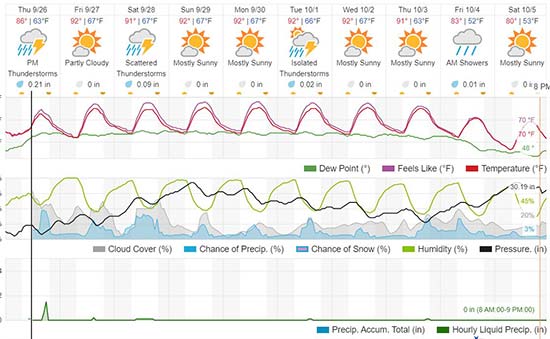
WHAT TO EXPECT
This morning comes with increasing clouds, and isolated rain. We have isolated showers, and a rumble of thunder is possible. The low is around 65 degrees.
We have another front coming through Thursday, this time bringing a few showers and storms to our area. We're are looking at a 40% coverage of our area in rain and storms. The latest pace puts these moving through our area in the late afternoon to evening.
Today's high isn't too bad, between the clouds and rain chances, as we reach to around 85 degrees. It is humid again though, so it feels several degrees warmer.
LOOKING AHEAD
Tonight will become partly cloudy, with patchy fog. We'll have a light breeze and temperatures dipping into the low 60s, around 64 in Knoxville.
Behind this, we warm-up!
Friday is right back to a high of 90, with scattered passing clouds and isolated pop-up showers and storms, 20% coverage of our area. It's humid, so it feels about 3 degrees warmer.
Saturday and Sunday will be in the low 90s, so by the end of the weekend will be in another heat wave. We're looking at isolated pop-up showers and storms, mainly along our elevation changes. The humidity continues to make it feel hotter. We'll see a little more sunshine on Sunday versus Saturday.
Highs of 90+ are likely on into next week, which will put us around more record highs until the end of the week.
We're watching a stronger push of cooler air. This will bring in showers Thursday, and the potential for some cooler days starting next Friday.