

Several Atlantic tropical threats to join Florence into mid-September; US at risk for additional hits
Following Gordon, major hurricane Florence will lurk while additional tropical threats are likely for the United States, Central America and the Caribbean islands into mid-September.
"We may have as many as three named tropical systems in the Atlantic at the same time next week,"according to AccuWeather Hurricane Expert Dan Kottlowski.
September is the peak of the Atlantic hurricane season and indications are that will be true to form with the potential for additional systems to form over the next couple of weeks.

This animation shows the entire tropical Atlantic basin on Tuesday, Sept. 4, 2018. Gordon is located in the upper left, while Florence is right of center. A potential tropical system is located on the far right, just off the coast of Africa. ( NOAA / GOES )
A parameter that tracks rising air in the tropics has the Atlantic basin in the red hot zone for tropical activity. Rising air is associated with storms.
As Gordon moves inland, weakens and unloads torrential rainfall over the central U.S., Florence will stay alive over the central Atlantic.
Florence reached hurricane status on Tuesday and became the first major hurricane of the 2018 season on Wednesday morning.
While Florence is forecast to fluctuate in strength, most scenarios bring the system close enough to the Atlantic coast of the U.S. and Canada to pester fishing, shipping and coastal interests with rough seas and surf starting this weekend.

Swells from the distant storm will propagate outward thousands of miles. Meanwhile, east to northeast winds will increase seas and surf along the Atlantic coast well in advance of Florence.
There is the scenario that Florence does not turn away before reaching the U.S. Atlantic coast and makes landfall with impacts of a powerful hurricane.
Prior to a direct threat on the U.S., interests in Bermuda should keep a close eye on Florence for possible strong winds and heavy rain, in addition to arisen seas.
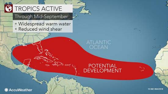
At this point of the hurricane season, ocean water temperatures in the tropical Atlantic are at their warmest point, while disturbances, known as tropical waves, roll frequently westward off the coast of Africa. This is known as the Cabo Verde or Cape Verde season.
The massive area from the African coast to the Caribbean, Gulf of Mexico and southern Atlantic coast bear most of the seeds for tropical storm formation in September.

Indications are that two to three new tropical systems may bud and develop in the eastern and central Atlantic this weekend into next week.
"It is possible that at least one of these features will wander close to the Lesser Antilles during Tuesday or Wednesday of next week,"Kottlowski said.
"At the same time, Florence may be hitting Bermuda."
Another disturbance is forecast to push westward, off the coast of Africa next week.
"That may become a tropical storm or hurricane,"Kottlowski said.
There is also the potential for a tropical system to arise in the swath from the western Caribbean to the central and western Gulf of Mexico next week. Steering winds may guide any such system near portions of Central America, southeastern Mexico and perhaps the Texas coast.
That western Gulf storm may be more of a long-shot, Kottlowski admittted.
"But, there may be some weak storm in the vicinity of the western Gulf next week,"Kottlowski said.
The next names on the list of tropical storms in the Atlantic for the 2018 hurricane season are Helene, Isaac and Joyce.
It is too early to imply that any of these features will definitely threaten land. However, the situation merits close monitoring for permanent and vacation interests in the Caribbean, Gulf of Mexico and western Atlantic in the coming days.
The basin is already significantly more active than it was a month ago and is likely to get even more active over the next couple of weeks.
Close to an average number of Atlantic tropical storms and hurricanes is predicted by AccuWeather with 10-12 named systems. The 2018 season is slightly ahead of the average pace at this point.
The seventh tropical storm typically forms on or about Sept. 16. Gordon formed on Sept. 3. Of these, only three have become hurricanes.
Chris came close to becoming a major hurricane (Category 3). On average, there is usually one major hurricane by Sept 4. Florence reached Category 3 strength on Sept 5.
Meanwhile, in the Pacific, Normal will pass north of Hawaii with rough surf this week. However, a new threat may arise next week.
"There is a chance that Olivia may survive the westward trip across the Pacific and hit Hawaii around the same time Florence is near Bermuda and Helene may be reaching the Windward and Leeward Islands in the Caribbean,"Kottlowski said.
"Next Tuesday could be a real bad day for tropical activity in general in the Western Hemisphere."