

Relentless rain to raise risk of flash flooding in eastern US into this weekend
A flow of tropical moisture will keep areas from the Southeastern states and the mid-Atlantic to the Ohio Valley wet into this weekend.
Rain will spread northward into the eastern Great Lakes and New England during the weekend.
People with outdoor plans and projects will be greatly challenged by the frequency of rain. Meanwhile, enough rain may fall at a fast enough pace to cause urban and small stream flooding.

While the areal coverage of rain and thunderstorms will be the most extensive during the afternoon and evening hours, downpours and thunder can occur around the clock in this weather pattern.
Recent rainfall has left the ground saturated in parts of the East.
The combination of prior rain and additional rain anticipated may lead to minor flooding along unprotected areas of some of the rivers, such as the Potomac, Conestoga, Millstone, Raritan and Rappahannock.
From Wednesday to this weekend, a general 1-3 inches of rain is likely with the potential for additional rainfall to approach 6 inches.
In a large part of northern Virginia, eastern West Virginia, Maryland, Pennsylvania and New Jersey, it would only take about 1 inch of rain in an hour to trigger flash flooding.
A similar condition exists over parts of the southern Appalachians and Piedmont areas.
Storm that originated from the tropics to enhance rainfall
A system that has taken on some tropical characteristics, or a weak subtropical feature, will push northward over the next several days amid the showers and thunderstorms.
At times, this storm may enhance the rainfall and thunderstorms along the way.

Areas that may experience enhanced rain and thunderstorms into Wednesday night include portions of the Florida Panhandle, southern Georgia and southeastern Alabama.
On Thursday and Thursday night, the enhanced rainfall and thunderstorms will push northeastward from northern Georgia to southern Virginia and West Virginia.
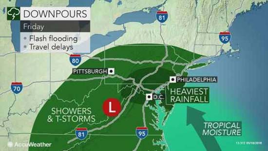
On Friday, torrential downpours and locally strong thunderstorms are likely to focus on the mid-Atlantic region.

And finally, during Friday night into Saturday, downpours are likely to drench the eastern Great Lakes and part of New England.
Break of dry weather to advance eastward this weekend
In the wake of that storm, a pocket of slightly drier air may be enough to turn off or at least tone down the downpours in part of the East this weekend.
This lull may extend eastward from the lower Mississippi Valley to the southern and central Appalachians and Piedmont areas on Saturday.
The rainfall gap may shift eastward toward the mid-Atlantic coast and much of New England on Sunday. However, downpours may reload over the Mississippi Valley and Appalachians by Sunday afternoon.