

Gulf Coast to face bouts of rain, downpours late this week in the wake of Michael
Following generally dry and seasonable weather early this week, heavy rain and tropical downpours are expected to return to areas devastated by powerful Hurricane Michael late this week.
“Not only could more rain fall on some saturated and flooded areas of Texas through midweek, but it could also reach locations in northern Florida and southern Georgia,”AccuWeather Senior Meteorologist Alex Sosnowski said.

Some moisture extended into western portions of the Florida Panhandle and the southernmost counties of Georgia on Tuesday, but this would only be a nuisance rather than a hindrance to recovery efforts.
A much larger storm will brew once moisture from what is currently Hurricane Willa just off of Mexico's southwestern coast in the eastern Pacific reemerges into the Gulf of Mexico by midweek.
Although Willa will have lost nearly all of its wind intensity by the time it reaches the Gulf of Mexico, its moisture is expected to spawn a new non-tropical storm that tracks eastward along the Gulf Coast.
After a tranquil day on Wednesday, drenching thunderstorms and soaking downpours will move into the Florida Panhandle and Georgia on Thursday and continue into Friday.
A general 1-3 inches of rain is forecast across portions of Alabama and Georgia, as well as in northern Florida. Unfortunately, a narrow corridor of 3-6 inches of rain will be possible between Panama City and Cedar Key, Florida, in areas hit hardest by Michael.

Because a prolonged stretch of dry weather since Michael has allowed area rivers and streams to fall well below flood stage, the additional rain should not be enough to cause another round of widespread, major flooding.
However, flooding of streams, creeks and streets at the local level will be possible in areas hit by the most persistent downpours.
The bigger impact from the rain will be to severely hinder and undo some of the progress made since Michael unleashed its wrath on the region.
Because the foundations of roads, buildings and structures still standing across the region have been severely compromised, any additional rainfall could cause road closures and additional washouts, as well as home collapses.
"The sandy soil in the region will absorb a great deal of water. However, where storm drains are filled with sand or blocked by debris, there is an elevated risk of urban flooding,"Sosnowski said.
Localized flooding issues could undo recovery efforts by washing away roads and homes still in their infancy of reconstruction.
"People who have begun the long process of repair and drying out homes and personal items may need to expedite waterproofing operations or potentially face more water damage from the late-week rainstorm,"Sosnowski said.
At the very least, the rain will put rebuilding and road construction efforts temporarily on hold during the latter half of the week.
Rain will also fall farther north in the Southeast states.
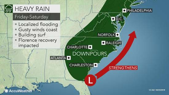
"Wet weather is in store for the northern parts of Mississippi, Alabama, Georgia and the Carolinas as the storm moves along and attacks the dry air in place to end this week,"Sosnowski said.

"Many of these areas can take some rain at this point. But, if the storm strengthens quickly, flash and urban flooding problems may develop in the Carolinas, Virginia and the Northeast."
The good news is that drier, less humid and more comfortable air ideal for the renewal of recovery efforts will settle into the Southeast by the weekend as the storm wraps up into a nor’easter for the mid-Atlantic and New England states.